Wareham & Studland – 4th June 2016
Old Harry Rocks
Old Harry Rocks are at the eastern extremity of Purbeck and are chalk sea stacks. This is the same geology as that of the Island’s central chalk ridge. Chalk formed in the late Cretaceous era, commencing a little over 100 million years ago, extending to about 66 million years ago. Chalk is actually a very pure form of limestone which was laid down in the sea. The sea level during the late Cretaceous was as highest the world has ever known. This thick layer of chalk was subject to folding during the Alpine Oroginy, from about 23 to 14 million years ago, although there is evidence of some folding before this event. This folding formed the geological structure know known as the Hampshire Basin, the syncline to the north of the chalk ridge, and an anticline, which formerly existed over what I term the ‘Southern Vale’ of the Isle of Wight. This folding resulted in the up-ending of the chalk strata of the ridge running through Purbeck and the length of the Isle of Wight.
Thousands of years ago there was a land bridge connecting the two areas with the chalk ridge forming its spine. The Isle of Purbeck, which is not really an island but a peninsula, would have formed the base of a much longer and broader peninsula which included the area which is now the Isle of Wight. The division of this peninsula into what is now Purbeck and the Isle of Wight was due to sea level rise. The drainage pattern would also have been very different before this rise in sea level, with the rivers Frome and Piddle, as well as the Avon which now enters the sea near Christchurch, discharging into the ‘Solent River’ before forming an estuary somewhere to the south-east of what is now the Isle of Wight, having been joined by the Test, Itchen and Medina and other rivers. The lower Solent River channel migrated widely in the area off shore from Bembridge and St Catherine’s Point due to sea level changes during and between the Pleistocene glaciations. The land bridge would have been breached long before the episode of sea level rise after the most recent glaciation, known as the Flandrian Transgression, which commenced about 12,000 years ago. Three significant palaeovalleys have been identified dating from before the Flandrian Transgression. These would have divided the upper reaches of the Solent River, with the Frome/Piddle and probably the Avon/Stour systems being diverted southwards through these breaches. The final separation of the Isle of Wight from the mainland was a product of the Flandrian Transgression. There is a division of opinion about the date of this final separation of the Isle of Wight. The BGS guide to the Isle of Wight gives a date of between about 7,000 and 7,500 years ago, whereas the publication of the Mesolithic occupation at Bouldnor Cliff says that the earliest possible date was 5,500 years ago.
The Isle of Purbeck is the beginning of the ‘Jurassic Coast’ which extends westwards from Old Harry Rocks along the coast of Dorset into east Devon. When I was at school I remember learning something about ‘Atlantic coasts’ and ‘Pacific coasts’. The eastern end of Purbeck is an ‘Atlantic coast’. The coast is at right angles to the geological stratigraphy, which when subject to coastal erosion produces a coastline of headlands and large bays. The south coast of Purbeck is a ‘Pacific coast’ with the coastline parallel to the geological stratigraphy. This results in a coastline with extensive lengths of cliffs punctuated with small bays, for example Freshwater Bay on the Island, Kimmeridge Bay and Warbarrow Bay in Purbeck, and Lulworth Cove further to the west.
With Purbeck and Wight sharing a common lateral chalk ridge there are similarities in the geology and geomorphology of both areas. The chalk ridge is punctuated by ‘wind gaps’ with no surface drainage such as that between Ballard Down and Goldingstone Hill in Purbeck, and the gap between Brook Down and Chessel Down on the Island. Where there are deeper gaps in the chalk ridge both have river systems that were superimposed on the modern geological structure, Corfe River here in Purbeck at the ‘gap of Corfe’ and the Medina and two Yar rivers on the Isle of Wight.
There are significant differences between Purbeck and Wight which are related to the underlying geology which in turn had an influence on its landscape history. Much of the Island to the north of the lateral chalk ridge is underlain by Hampstead Beds and Bembridge Marls which had a vegetation cover predominantly of wet heathland and wood-pasture in the early middle ages. The north of the Isle of Purbeck is underlain by Barton, Bracklesham and Bagshot Beds which have resulted in an historic land use of dry heathland, which is still very much in evidence. This was part of the extensive tract of heathland celebrated by Thomas Hardy in The Return of the Native, where Wildeve’s Patch was ‘redeemed from the heath’. The area to the south of Purbeck’s chalk ridge does not have a wide Lower Greensand vale as on the Island with its extensive areas of dry heathland in the early middle ages. Instead, the central vale of Purbeck is narrower and underlain by Wealden Beds, which would suggest a different type of ‘landscape of colonization’ with wetter soils, akin to the Wealden area of the Island’s south-west coast in the Brighstone and Brook areas. Purbeck does not have a southern chalk massif, but instead an area of Jurassic Purbeck Limestone forming a plateau along its southern coast. Here in the area to the south of Swanage and Langton Matravers there is an extensive area of north-south linear field boundaries which may have had their origins as early as the Bronze Age. To the west of this the Purbeck Limestone forms the promontory of St Aldhelm’s Head.
Reference:
Hopson, P.M. & Farrant, A.R. 2015 Geology of the Isle of Wight, British Geological Survey
St Nicholas Church, Studland
The church dedication
Studland church is dedicated to St Nicholas. He was later identified with Father Christmas but in the medieval period was known as St Nicholas of Myra. I recommend a visit to Winchester Cathedral to see the splendid black Tournai marble font dating from the twelfth century which shows scenes from his legendry life. The dedication of medieval churches to St Nicholas had a connection with the sea. Studland church is within 250 yards of the sea. St Nicholas at Worth Matravers is about 1,000 yards from the southern coast of Purbeck. The excellent study of Kentish settlement by Alan Everitt includes a study of medieval church dedications. Everitt says that “In Kent, as in other maritime counties, the unusual popularity of St Nicholas, the patron saint of mariners, is in part attributable to these circumstances [an association with fishermen and mariners]; for eleven of the 34 churches bearing his name were on tidal water, and a further eight within three miles of it” (p 232-3). Of these 34 churches in Kent dedicated to St Nicholas, all but one appear to have been subordinate establishments. This would also seem to have been the case at Studland, assuming that Studland church was a daughter church of St Edward’s, Corfe Castle.
Outside the church
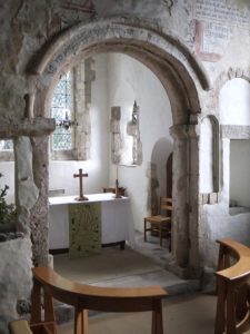
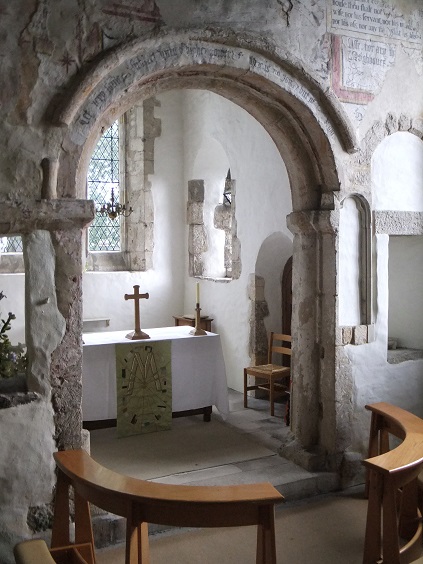
Several publications about the church have said that the present building started life as an Anglo-Saxon church which was partially encased in ashlar in the Norman period. The study by Karen Lundgren and Malcolm Thurlby published in the Dorset Proceedings for 1999 has disproved this. Why would anyone bother to do this? What we have is a splendid Norman parish church probably dating to after 1125 and completed by 1140. Its ground plan can be described as having an axial tower between the nave and chancel, but without aisles or transepts. Lundgren and Thurlby concluded their paper on the church by saying that “With its rib-vaulted eastern bay and tower, and richly sculptured corbel table, it is one of the best examples of parish church architecture in Norman England”.
Much of what can be seen dates from the earlier twelfth century. It is not quite as built. The lancets of the east window were inserted in the thirteenth century, the larger windows on the south side of the church are enlargements made in the eighteenth century, and the porch was added in the nineteenth century.
The first external feature to note is the corbel table. This extends the length of the nave on the south and north sides. Several of the corbels are grotesque, and three are of a sexual nature. Above the porch there is a copulating couple. Towards the west end of the southern corbel table there is a man with very large testicles. This has been examined in detail by Malcolm Thurlby who says that the figure is missing his erect male member, presumably having been removed at the Reformation or during the mid seventeenth century by people of a puritanical frame of mind. Around on the north side of the church is a shiela-na-gig. This is a grotesque representation of female genitalia. There is an almost exact parallel to this exhibitionist at the splendid twelfth century church at Kilpeck in Herefordshire. What was the meaning of these corbels to a twelfth century audience? Karen Lundgren and Malcolm Thurlby in their paper discuss the corbels here at Studland. They say that many of the corbels do not carry any sinister connotations, and those with simple geometric designs seem to be just for decoration. Regarding the corbels of a sexual nature, Lundgren and Thurlby say that “Far from being illustrations of love and union, these Studland corbels are images of lust intended to allay passions by distorting the figures into grotesques” (p. 12). These corbels were thus a warning to the parishioners of Studland.
The north and south windows of the chancel are both original. It is interesting to note that they are of a very similar form to a Romanesque window recorded at Newchurch by Sir John Gardner Wilkinson in the 1840s, now long gone.
Inside the church
The original south doorway has a plain tympanum. These were usually carved with geometric decoration such as at Yaverland or figural sculpture as at Shalfleet. It is quite possible that the tympanum here was painted, but as it was exposed to the elements for several hundred years until the porch was constructed there will be no evidence of this.
The general impression of the church interior is austere. The interior walls of the church would have been painted with an array of biblical and other religious themes, alas now long gone. There traces of wall painting above the north dooway in the nave.
The nave has a wooden roof. This is in contrast to the tower and chancel which are rib vaulted. The tower has ribs carried on cushion capitals. The chancel also has a rib vault. Rib vaulting was a relatively new technology when the church was built, having been introduced in the 1090s. The decoration on the capitals of the tower arch and chancel arch were probably originally painted. The interior of a medieval parish church would have appeared garish to modern taste. Some idea of what it may have looked like with painted architectural details and wall paintings can be gained from St Martin’s church at Wareham. The best example of the survival of Romanesque wall painting that I have come across is the early Norman church of Kempley in Gloucestershire. I have not visited the church at Copford in Essex where the Romanesque wall paintings were repainted in the nineteenth century (a practice which would be frowned upon now) but which gives an impression of a relatively newly painted church interior, broadly contemporary with Studland church.
The origins of St Nicholas church
The twelfth century church here at Studland may have been a replacement of an earlier structure. Domesday Book does not mention a church here. This in itself has little significance. The Island has several churches which were in existence by 1086 but were not itemised in Domesday Book. St Nicholas is alongside Manor Farm. This combination of manorial centre and parish church is a widespread phenomenon in the English landscape. Examples from the Island include Wootton, Gatcombe, Yaverland and the old church at Thorley. The possession of a church was a mark of status in the later Anglo-Saxon period and into the Norman period. This was an important driving force for the provision of local churches.
The association of church and manor and the motivation of a local lord may not however be the whole story explaining the building of St Nicholas church. Many local churches associated with manorial centres were relatively simple structures when first built, for example the two cell plan of Yaverland and the single cell plan of Wootton. The fineness of the architecture and the sophistication of the ground plan at Studland would suggest patronage other than a local lord wanting to make good. In 1086 Studland was held by Robert, Count of Mortain, half-brother of King William, who held more land than any other follower of William the Conquerer. Robert was not your average local lord. I do not know anything about the landholding of Studland in the period 1125 to 1140 when the church was probably built (as this part of Dorset does not have a Victoria County History) but the Domesday evidence would suggest that Studland was still part of an extensive landholding. Karen Lundgren and Malcolm Thurlby have considered the patronage of the church here at Studland. They say that whilst a patron cannot be identified, a number of parallels between Studland and Romsey Abbey, including the rib vaults, arch mouldings and the corbel table, suggest that the master mason at Studland was recruited from Romsey Abbey. St Nicholas at Studland was not your average Norman parish church, but something rather special.
References;
Everitt, A. 1986 Continuity and Colonization: the evolution of Kentish settlement, Leicester
Lundgren, K. & Thurlby, M. 1999 ‘The Romanesque Church of St Nicholas, Studland (Dorset)’, Proc. Dorset Nat. Hist. Archaeol. Soc. 121, pp. 1-16
Wareham: the Anglo-Saxon town
Wareham is strategically situated between the rivers Frome to the south and the Piddle to the north, which drain eastwards into Poole Harbour. Much of the Anglo-Saxon burh was laid out on the river terrace. There is some evidence for prehistoric and Romano-British occupation within and around the town. Roman Wareham would appear to have consisted of two distinct sites, one in the area of the north-west corner of the later town, and the other in the area of Lady St Mary’s church. Wareham as a planned settlement originated in or by the later ninth century. Wareham had a recorded history before this date, for in the year 802 King Beorhtric of Wessex was buried here, probably at the minster church. This was on the site of the present day Lady St Mary’s church. The strategic importance of Wareham in the time of King Alfred just before the establishment of a system of burhs for the defence of Wessex is attested in the Anglo-Saxon Chronicle for 876: “Here the raiding-army stole away from the West Saxon army into Wareham …” (ASC E), and for 877: “Here the raiding-army came from Wareham to Exeter, and the raiding ship-army sailed around the west, and then they met a great storm at sea, and 120 ships were lost there at Swanage …” (ASC E).
In 1927 an early medieval sword was found during widening of the bridge over the river Frome. It can be dated to the tenth century due to the inlaid decoration on its guards, a date after the creation of the burh. Given the importance of the interaction between Danes and Anglo-Saxons in the story of early Wareham, it is perhaps appropriate that we don’t really know whether the sword is of Viking or Anglo-Saxon workmanship. Also in the tenth century Wareham played a part in the murder of King Edward the Martyr and the accession of his half brother Æthelred II in 878. As the Anglo-Saxon Chronicle records for this year “Here King Edward was killed in the evening-time on 18 March at Corfe ‘passage’; and they buried him at Wareham without any royal honours …” (ASC E). The body of Edward was not left for too long at Wareham, for two years later he was reinterred at King Alfred’s abbey of Shaftsbury where he was feted as Saint Edward, King and Martyr, a cult which developed in the early eleventh century.
Lady St Mary’s church
One of the great archaeological crimes of the nineteenth century was the demolition of the Anglo-Saxon minster church here with the rebuilding of the nave in 1841-2. It left our architectural heritage much diminished. This building was comparable to the fine eighth or early ninth century church of Brixworth in Northamptonshire, with porticus (side chapels). The site of Lady St Mary’s church was the burial place of King Beorhtric in 802, before the establishment of the burh here. We cannot be certain whether the building demolished in the nineteenth century had been constructed by the time of King Beorhtric’s death, but the evidence of the inscribed stones in the present church (see below) may suggest that the church was built after the year 802. It could possibly date to the time of Alfred, or even to the tenth century. The burial of the king here does however attest to the importance of Wareham before the time of Alfred’s burh with a minster church site which may have provided a focus for settlement. Lady St Mary was probably the focus for the convent of nuns referred to by Alfred’s biographer Asser and the residence of abbess Wulfwynn as recorded in the Anglo-Saxon Chronicle in 982.
When the church was demolished in the early 1840s, five inscribed stones were recovered. They had been broken up and used as rubble in the nave wall. Two of the five memorial inscriptions are cut on Roman columns. This fact could be seen as evidence for a substantial Roman building in the area, but the stones could just as easily have been brought in from elsewhere. None of the inscriptions appear to predate c. 600 with the latest c. 800. These stones can be seen in a British rather than Anglo-Saxon context, and have similarities with inscriptions from Wales. David Hinton has said that “The memorial stones … suggest a strong British church tradition there into the 8th century …” and that “the Wareham memorials are relatively more numerous than at other centres may be a accident of survival- the building of a new church at a point when the British tradition was redundant, its memorials no longer respected and available for use as rubble- or it may be because the British enclave there felt a particular need to stress its separateness against a tide of Saxon orthodoxy” (Hinton 1992).
Burhs
Burh is an Old English term which has connotation of defence. It had a broad range of meanings depending upon the context. Burh place-names refer to a variety of enclosed sites: Iron Age hill forts such as Danebury; some instances of Roman defensive sites, such as Canterbury and the Island’s own Wihtgarasburh; Anglo-Saxon royal and aristocratic residences for example Barton on Humber in Lincolnshire, Anglo-Saxon minster enclosures such as Bibury and Tetbury in Gloucestershire; and Anglo-Saxon fortified towns. On the Isle of Wight there are or were three place-names including the term burh, four if we include Harboro, which means ‘earthwork’. Barton in Whippingham parish was ‘burh-tūn’ and could record a pre-Viking Age fortification guarding the Medina estuary. It may however mean a settlement dependent upon a burh. Stenbury, recorded as such in Domesday Book, is probably best seen as the ‘stone burh’ and would appear to refer to a stone-built house in or before the later eleventh century which was incidentally defensible, and Wihtgarasburh of the Anglo-Saxon Chronicle of the sixth century is a reference to the later Roman ‘Lower Enclosure’ at Carisbrooke Castle. My own gloss on the meaning of burh is ‘defensible enclosure’ although even this would not encompass the meaning of Stenbury’s place-name.
With sites such as Wareham we can be a little more precise. Wareham is one of 33 burhs, mainly in Wessex, which were listed in the Burghal Hidage. This document, or rather the two versions which have come down to us, is conventionally dated to the first half of the 910s. The Burghal Hidage was a fundamental part of King Alfred’s defence in depth against Danish incursions, and the system of burhs would have been established after his victory at the battle of Edington in 878. These burhs were very diverse but provided a fortified place of refuge within 20 miles for most of the inhabitants of Wessex, but the Burghal Hidage excluded Cornwall, Kent and the Isle of Wight. Martin Biddle has classified the burhs of the Burghal Hidage. These categories are reused Roman walled towns, such as Winchester and Chichester; new towns on open sites with rectangular perimeters, for example Wallingford and Wareham; new towns on promontory sites with irregular perimeters, of which Malmsbury and Shaftsbury are examples; reused Iron Age or Romano-British forts, such as Chisbury near Great Bedwyn in Wiltshire and Porchester Castle; new forts for example Burpham in Sussex; and finally the single unclassifiable burh of Southwark. Wareham was a new site on an open site with a rectangular perimeter. The perimeter of Wareham and the basic plan of its internal road system would have been laid out as one event in time. Wareham had an eastern gateway, a northern gateway adjoining St Martin’s church and a western gateway, and an apparently undefended entrance to the south adjoining a presumed ford through the river Frome.
St Martin’s church
Newman and Pevsner in The Buildings of England: Dorset (1972) state that “Whereas for St Mary the Anglo-Saxon state of the building has to be deduced from a drawing, for St Martin Anglo-Saxon features are there for all to see- only they are less interesting. That does not mean, however, that within Anglo-Saxon evidence in Dorset St Martin is not of prime importance”. The eleventh century fabric was that of the chancel and much of the nave. The north aisle and south porch were later additions. The earliest church fabric is characterised by a building which is tall in relation to its width. The Anglo-Saxon workmanship is demonstrated by the eastern quoins of the nave and chancel, “all of which are of large stones laid with a distinct tendency towards long-and-short technique, which is particularly clearly shown in the north-east quoin of the chancel” (Taylor and Taylor 1965, 638). The north wall of the chancel has a single-splayed window, compatible with a late Saxon or early Norman date.
The chancel arch is also of significance in terms of Anglo-Saxon architecture. This is described in the following terms by Taylor and Taylor in their Anglo-Saxon Architecture: “The principal internal feature is … the chancel arch, which has survived almost intact despite the cutting of squints through the walls on either side of it. The proportions of the round-headed arch are perhaps Norman; but its detail is distinctly Anglo-Saxon, with a half-rounded soffit-roll on the arch and the jambs, and a hood-moulding of half-round section carried round the head of the arch” (p. 638).
St Martins Chancel Arch
The inside of St Martin’s church is renowned for, apart from its monument to Lawrence of Arabia, its medieval wall paintings. Roger Rosewell in his excellent book Medieval Wall Paintings (2008) says that “The earliest surviving English wall paintings of saints are those of St Martin of Tours, at Wareham (Dorset), and St George , at Hardham [Sussex], both made around 1100” (p.69). The painting here on the north wall of the chancel depict two scenes from the life of St Martin of Tours as a Roman officer on a horse. In the lower part he is giving his cloak to a beggar. In a vision he had later he saw Christ wearing part of the same cloak. The painting continues into the splay of the single-splayed window to the right. Here at Wareham we have a good correspondence between the dedication of the church and the subject matter of the earliest wall painting.
St Martin’s is a fine example of Anglo-Saxon architecture, but the term Anglo-Saxon workmanship would be more accurate. It would be quite appropriate to argue that the St Martin wall paintings are contemporary with the construction of the church in about 1100. Supporting evidence can be cited from the Taylor’s comments about the chancel arch and the single-splayed north window of the chancel. The church web-site gives 1030 as a date for construction, but a date some 70 years later is quite plausible.
St Martin’s is located at the north gate of the burh of Wareham. It was constructed on top of the defences. This type of situation is paralleled by St Michael’s Northgate in the burh of Oxford. It is possible that both St Martin’s and St Michael Northgate may have had a defensive function. This function can also be argued for the splendid late Anglo-Saxon church tower at Earls Barton in Northamptonshire.
The foundation of the burh
Three trenches were excavated across the line of the West Walls of Wareham in 1952-1954 by staff of Royal Commission for Historic Monuments. The excavation report concludes that: “In the light of the evidence and of the analogies outlined …. it seems reasonable to conclude that Phase I of the defences at Wareham represents the burh existing in Alfred’s day, and that Phase II, with the stone-faced rampart, belongs to an unrecorded strengthening at some pre-Conquest date. Either the renewed Danish threat in the reign of Aethelred II (979-1013) or the period of peace during the long reign of Knut (1016-I037) would prove a suitable setting for such a work”. I think that the former is much more plausible. It may be that the Royal Commission had got it wrong on the dating of the origins of the burh during King Alfred’s reign. A case can certainly be made for the first phase of the ‘walls’ predating Alfred’s victory at Edington in 878. This argument can be summarised thus:
• A Viking army overwintered at Wareham in the winter of 875 to 876. The existence of a burh here would have been an incentive for them to do this.
• The house of Wessex had the ability to construct and maintain burhs before the accession of Alfred in 871. The provision of labour for the building of forts was one of the ‘three common burdens’ in land charters during the reign of Beorhtric (786-802) but was not a regular feature in charters until the reign of Æthelbald (855-60).
Derek Gore in his paper in ‘Danes in Wessex’ states that
There are good reasons too why Wareham might have been chosen for fortification earlier in the ninth century. The site was accessible by sea and river and may have been a port. King Beorhtric was buried there, so it was most probably a royal estate as well as an early ecclesiastical centre with a small but significant group of early inscribed stones. Taken together, these elements demonstrate that Wareham was a key place which may already have had defences by 875 (Gore 2016, 60).
Manning the defences
Going back to the time of Alfred, the Burghal Hidage provides a formula for the manning of burhs:
For the maintenance and defence of an acre’s breadth of wall, sixteen hides are required. If every hide is represented by one man, then every pole [i.e.five and a half yards] of wall can be manned by four men. Then, for the maintenance of twenty poles of wall, eighty hides are required by the same reckoning as I have stated above … For the maintenance of a circuit of twelve furlongs of wall, 1,920 hides are required. If the circuit is greater, the additional amount can easily be deduced from this amount, for 160 men are always required for one furlong, then every pole of wall is manned by four men (Abels 1988, 74).
The Burghal Hidage recorded that Wareham was endowed with 1,600 hides. This would have been a substantial area which can be compared with the 200 hides or so of the Isle of Wight in 1066.
Excavations within the defences
The excavations in the 1970s on North Street were of limited extent compared with say the excavations by Martin Biddle of early medieval Winchester, but they provided valuable information about the development of the burh at Wareham. The planning of the burh did not result in the creation of a fully functioning town. The excavations would suggest that the primary function of Alfred’s burh was defensive. The excavations on North Street site in the 1970s indicated that none of the features excavated there need pre-date the Alfredian burh. The increasing number of features excavated and the quantities of pottery agues for a development of population in this area of the town during the tenth and eleventh centuries, and David Hinton has argued that this growth explains the need for the construction of St Martin’s church in the eleventh century. Hinton has also pointed out that we should not over emphasise the rectilinear nature of Wareham’s street plan as a creation of the ninth century. The principal axes, North Street/South Street, and West Street/East Street would have been established then. The excavation has shown that at least one of the internal streets, Dollins Lane, was a development of the thirteenth century or later. The setting out of Wareham in the tenth century cannot be equated with post Conquest planned towns where the whole street pattern was laid out as one event, often as a speculative venture, for example Newport, Yarmouth and Newtown Isle of Wight. Wareham grew as a town in a piece-meal fashion over time.
Wareham Castle and Domesday Book
The castle of Wareham was imposed upon the Anglo-Saxon town plan. The information in Domesday Book is difficult to interpret but does imply that the castle had been constructed between 1066 and 1086 with the destruction of dozens of houses. There is now not much to see of the castle here in the south-west corner of the town, but a rectangular keep is known from excavation. This would probably post-date the time of Domesday Book. The outline of the castle’s bailey is reflected in the street pattern, here not rectilinear but curving around the outside of the castle. The twelfth century doorway in Pump Lane would appear to have been something to do with the Norman castle.
By 1066 Wareham would have been a fully-functioning town, although a significant proportion of the houses here were destroyed with the building of the castle before 1086. There had been 143 houses in the King’s demesne in 1066, and there was a mint with two moneyers. The Domesday entries for Wareham include references to landholders in outlying settlements holding houses in Wareham. Jeremy Haslam has quite recently published his research into the relationship between the Alfredian burhs of Wessex and the phenomenon of rural landholders in Domesday Book having houses in towns that were burhs. Whilst Haslam did not publish a case-study of this for Dorset, it would appear that here at Wareham we have a reflection of the provision for the defence in depth, i.e. Alfred’s burhs, in the Domesday returns for the county. The three named settlements of Creech, Littlemayne and Lytchett Matravers would have been within the area of the 1,600 hides defined for the maintenance and manning of the burh of Wareham.
Conclusions
We can summarise the various themes explored: Wareham had Romano-British occupation; it would appear to have had significance as a British enclave before about 800; it was the location of a probable pre-Viking age minster church; it was a site of strategic importance to Viking invaders and to the royal house of Wessex in the ninth century; it was laid out as a defensive burh by the late ninth century; it was refortified, quite probably in the ‘Second Viking Age’ during the reign of Æthelred II; it developed into a fully-functioning town during the tenth and eleventh centuries, before being partially destroyed with the construction of the castle. It was also the burial place of two kings of Wessex who claimed descent from Cerdic. The place-name Wareham means ‘the settlement by the weir’. Thomas Hardy renamed towns in his Wessex novels. In The Return of the Native Wareham became Anglebury, an appropriate name given its origin as a burh and its rectilinear street pattern.

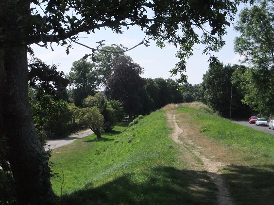
Wareham from the South Wareham Eastern Earthworks
References:
Abels, R. P. 1988 Lordship and Military Obligation in Anglo-Saxon England
Gore, D. 2016 ‘A Review of Viking Attacks in Western England to the Early Tenth Century: Their Motives and Responses’, in Lavelle, R. & Roffey, S. (eds.) Danes in Wessex, pp. 56-69
Haslam, J. 2014 Urban-Rural Connections in Domesday Book
Hinton, D. A. 1992 ‘The Inscribed Stones in Lady St Mary Church, Wareham’, Proc. Dorset Nat. Hist.. Soc. 114, p. 260
Hinton, D. A. & Hodges, R. ‘Excavations in Wareham, 1974-5, Proc. Dorset Nat. Hist. Archaeol. Soc. 99, pp. 42-83
Newman, J. & Pevsner, N. 1972 The Buildings of England: Dorset
RCHM 1959 ‘Wareham West Walls’, Medieval Archaeology 3, 120-138

You must be logged in to post a comment.