
An Investigation into the structure of a bank followed by the Newchurch/Arreton parish boundary at Mersley Farm, Newchurch. Isle of Wight.
David Marshall
In July 2019, the Isle of Wight Archaeological Society undertook an investigation of the parish boundary at Mersley Farm (SW 556869) in the parish of Newchurch (Figure 1). The boundary currently follows a low bank that was calculated to be slightly less than one metres in height . The boundary separates the parish of Newchurch from its western neighbour, the parish of Arreton.

Figure 1. Location of medieval parish boundary bank Mersley Farm, Newchurch Isle of Wight
The mother parish of Newchurch is thought to have been established in the late 7th century, early 8th century (Hockey 1982 2) following the subjugation of the purported pagan Isle of Wight (Bede in Hockey 1982 1) by Caedwalla in AD686 (Arnold 1988 215). Newchurch was one of seven mother parishes that have been described as ‘bacon rasher’ shaped parishes, running across the island from north to south. The responsibility for the establishment of the seven mother parishes and their boundaries is thought to have been Daniel, Bishop of Winchester (Hockey 1982 1).
Yorke (2018 36) suggests that the ‘pagan’ description of the island was a convenient reason for Caedwalla to add the Isle of Wight to a growing Wessex hegemony following the earlier annexation of the South Saxons in AD 686. Allied to this was the need for Wessex to secure a safe sea passage from the Solent to continental Francia. It is perhaps no coincidence that a secure Hamwic was established adjacent to the Solent shortly after in the late 7th and early 8th centuries. The Isle of Wight productive sites at Bowcombe and Shalfleet (Ulmschneider 2003 98; 2013 87-98) have been linked with the emporia at Hamwic.
Newchurch mother parish stretched across the island from Ryde in the north to Ventnor in the south. It would be wrong to conflate the medieval parish boundary and the presence of a bank. It is possible that the bank is a much earlier boundary than the parish boundary which may have followed a pre-existing line in the landscape. There is no bank on the eastern edge of the parish to the north of the East Yar.
The archaeology of Mersley Farm
Trott referred to the Mersley Farm landscape as one of multi-period occupation (Trott 2000 95-112). A field walking assessment recorded worked flint, ceramics of Iron Age, Roman-British, Saxo-Norman. Medieval and post Medieval dates (Trott 2000 113-116). Tomalin (1988 97-102) reported on a 4th century corn drier. In 1998 details of a Late Iron Age ceramic assemblage which was found near the corn-drier was revealed (Tomalin 1998 97-102).
The site
The boundary bank runs from the southern perimeter of what was possibly common land on Mersley Down, descending the scarp slope. Below the scarp is gently sloping farmland down to the East Yar. The boundary terminates prior to the East Yar where it follows a tributary for a short distance. The bank does not continue south of the river (Figure 2).
The part of the boundary bank to be investigated is located on a geology of Ferruginous Sands. This geology gives a slightly acidic but fertile soil often improved by the addition of Chalk marl. The horizon below 350mm gradually assumes a higher clay content.
Objectives
1. Investigate the method of construction of the bank.
2. Look for any dating evidence contained within the bank.
3. To confirm the current height of the bank.

Figure 2. Extract from the 6” ordnance Survey Map 1863 showing location of boundary bank at Mersley Farm
The part of the boundary bank to be investigated is located on a geology of Ferruginous Sands. This geology gives a slightly acidic but fertile soil often improved by the addition of Chalk marl. The horizon below 350mm gradually assumes a higher clay content.
The test trench

It was decided that the test trench would be an excavation of the eastern half of the bank because the bank is shared with the neighbouring landowner. The trench was cut to a width of 700mm to a depth of 810mm (centre of test trench) until the level of the fossil ground level was achieved although the deepest part of the test trench was 900 mm. The excavation was continued for a further 140mm to collect a soil sample for a later pollen analysis and to look for any dating evidence below the original land surface. Five contexts were observed and are shown in Figure 3 and described below.
Discussion
An auger was used to identify the source of the material used for bank construction. This revealed that the material used was borrowed from a ditch dug at the western side of the bank. The ditch has now disappeared as hill wash from both the neighbouring farmland and from the bank have infilled the ditch.
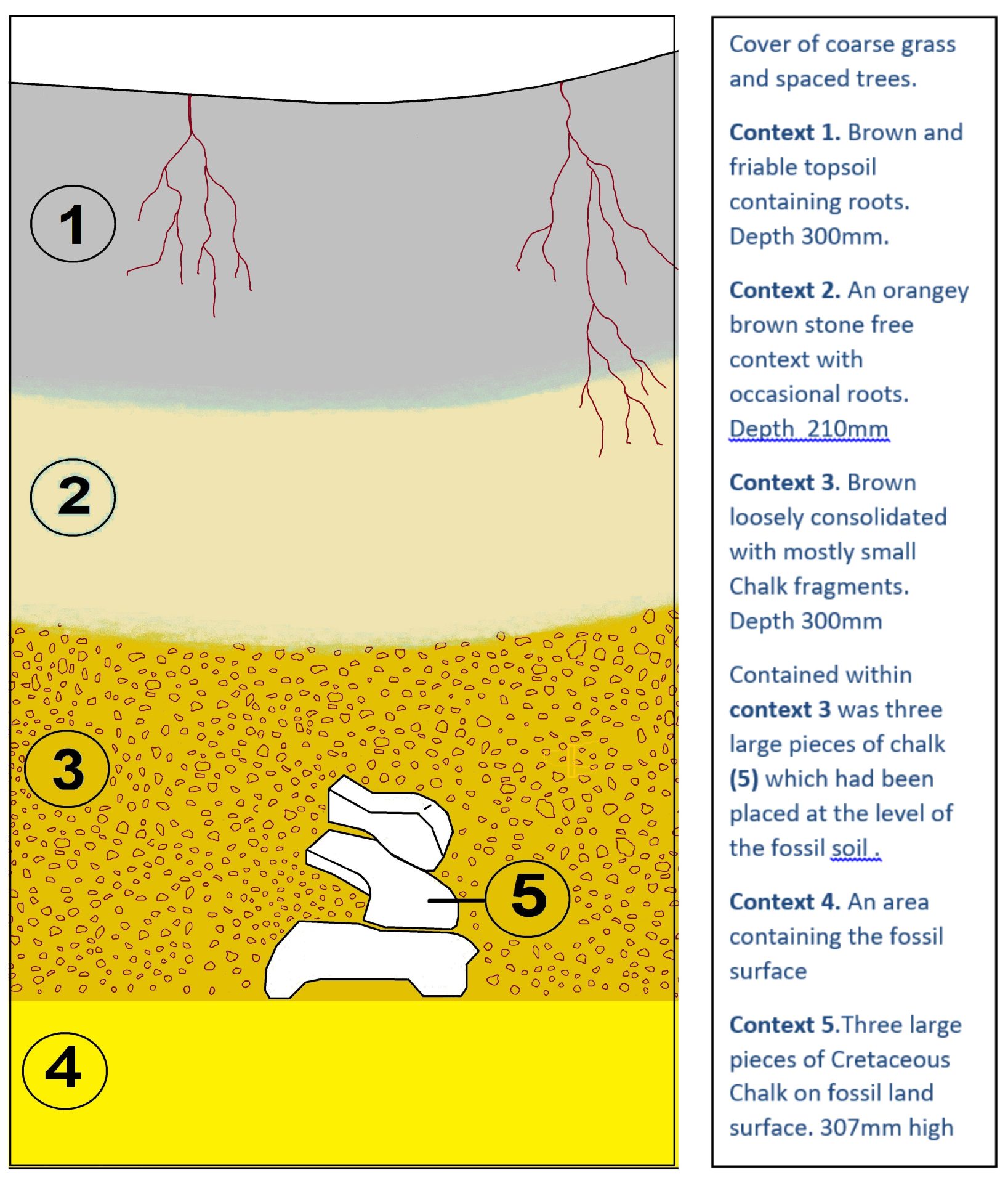
Figure 3. – Boundary bank contexts. Mersley Farm, Newchurch Isle of Wight
The structure of the bank revealed in contexts 1 to 3 suggests a reverse order to that of the material taken from the ditch. Context 3 which contained the small fragments of Chalk suggests that the chalk has resulted from marling of the original land surface and thus represents former topsoil. Context 2 has a very similar colour to that of the Ferruginous Sand that underlies the topsoil. Context 1 would seem to have had sufficient time to develop into a topsoil although the sandy texture found in the local topsoil is less evident in the topsoil of the bank.
The large chalk rock found on the fossil land surface may have been used to mark the route that the boundary bank was to take. It would take further lateral extension of the trench to confirm this and also the distance between markers should the use of the chalk be confirmed. Unfortunately, it was not possible to undertake an extension of the trench.
The test trench was over deepened to reveal dating evidence, but none was found. While further excavation may prove successful perhaps OSL (Optically Stimulated Luminescence) may provide a date for the construction of this bank.
Figure 4 clearly shows the bank followed by the parish boundary; the slope of the land on the west of the bank would encourage the build-up of soil against the bank. The image indicates the land surface east of the bank to be lower. Farming activities on the eastern side of the bank would progressively lower the land surface with the movement of soil downslope on the western side would be prevented by the bank. The field boundary to the west, which runs parallel to the boundary bank, adds credence to a hypothesis that the bank may initially have been a field boundary. However, it is not known if all field boundaries benefitted from being marked out in this way, or only the significant boundaries. This would include the dominant field boundaries that largely remain untouched incorporating land from the watershed on the Downs to the valley floor. However, this is speculative until these fossil field boundaries such as that to the west of the parish boundary in Figure 4 can be shown to have been planned in this way. If these field boundaries are not planned by prior marking then it has to be considered that it is only the more important territorial boundaries have to be carefully planned, agreed and then subject to formal marking out.
The quarry pit on the slope below Mersley Down and the track leading from it suggest a very local source for the chalk marl found in the bank test trench.
Footnote
The Iron Age Hill Fort at Penycloddiau in North Wales appeared on the ‘Digging for Britain’ television series in 2017. When the rampart was excavated it was found that its siting had been determined by placing blocks of stone at intervals to mark the route it was to take.

Figure 4. Lidar image looking south from Mersley Down
Summary
The test trench and review of the landscape has given a better understanding of the construction of the boundary bank. Unfortunately, no dating evidence was found. It is clear that this bank cannot be referred to as a ‘medieval parish boundary bank’ until accurate dating can suggest close association between both the date of the bank and that of the establishment of the mother parishes or, indeed, an earlier boundary. The bank followed by the parish boundary was found to be asymmetrical in shape caused by hill wash erosion from the fields to the west and arable farming to the east. Similar investigations across the island are required to explore further the relationship between those parish boundaries that are associated with a bank.
Bibliography
Hockey, S. F. Insula Vecta 1983 Phillimore. London and Chichester.
Tomalin, D. J. A. Late Iron Age ceramic assemblage from a possible burial context at Packway, Newchurch, Isle of Wight Proceedings of the Natural History and Archaeological Society. 1988 Volume 14 95 -97.
Tomalin, D. J. A. mid-C4th corn drier at Packway, Newchurch Isle of Wight. Proceedings of the Natural History and Archaeological Society. 1988 Volume 8 43-55.
Trott, K. Evaluation excavation at Mersley farm Newchurch Isle of Wight Proceedings of the Natural History and Archaeological Society. 2000 Volume 16 95-112.
Trott, K. Mersley Farm Field Walking assessment 2000 Proceedings of the Natural History and Archaeological Society 2000 Volume 16 113- 116.
Trott, K. An assemblage of Roman Pottery and Building Material from Packway, Newchurch Isle of Wight Proceedings of the Natural History and Archaeological Society. 2002 Volume 18 47-54.
Yorke, B. 2018 The Middle Ages Revisited. Studies in the Archaeology and History of Medieval Southern England. Archeopress Archaeology. Oxford.
Ulmschneider, K. 2010 More Markets, Minsters, and Metal Detecting Finds: Middle Saxon Hampshire a Decade On in Henig M and Ramsey N (eds) Intersections. The Archaeology of and History of Christianity in England. Archeopress Archaeology. Oxford.
Ulmschneider, K. and Metcalf, M (2013) Sceattas and early broad pennies found in the Isle of Wight British Numismatic Journal.
You must be logged in to post a comment.